Table of contents
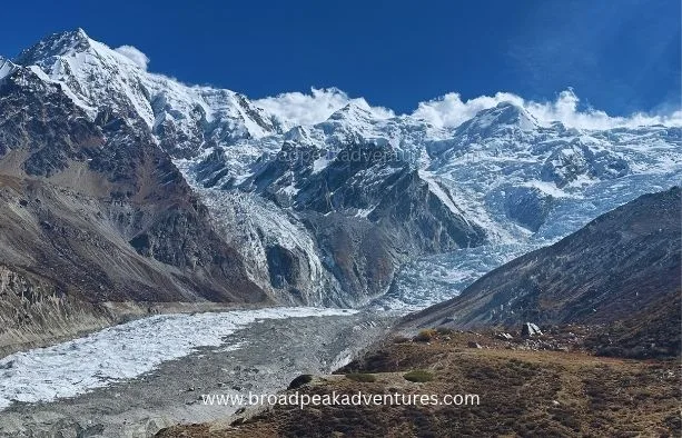
When people think of the Himalayas, they picture Nepal, India or Bhutan. Few realise that the range ends in Pakistan, and that it does so in spectacular fashion with one of the largest mountain faces on the planet.
Pakistan is also the only country where the Himalaya, the Karakoram and the Hindu Kush meet. We run treks in all three, and guests are often unsure which range they are actually standing in. This guide explains where the Pakistan Himalayas are, how they differ from the Karakoram and which places are most worth visiting.
Where Are the Himalayas in Pakistan?
The Himalaya runs for about 2,400 kilometres from east to west. Its western end lies in northern Pakistan, where the range is cut off by the great bend of the Indus River.
In Pakistan, the Himalaya covers the following areas.
- Diamer and Astore in Gilgit-Baltistan, which are home to Nanga Parbat
- The Deosai Plateau between Astore and Skardu
- The Kaghan Valley in Khyber Pakhtunkhwa, including Naran and Babusar Pass
- Azad Kashmir, including the Neelum Valley
- The foothills around Murree and the Galyat, north of Islamabad
A simple rule helps. In Gilgit-Baltistan, the land south and east of the Indus belongs to the Himalaya, and the land to the north belongs to the Karakoram.
Where Three Great Ranges Meet
About 40 kilometres south of Gilgit, near the village of Jaglot, the Gilgit River flows into the Indus. A roadside monument on the Karakoram Highway marks this spot as the junction of three mountain ranges.
Standing there, you look east towards the Himalaya, north towards the Karakoram and west towards the Hindu Kush. There is nowhere else on Earth where three ranges of this scale come together, and it takes only a five minute stop to see it.
Himalaya vs Karakoram: What Is the Difference?
The two ranges sit side by side and are often lumped together, but they are quite different in character.
| Feature | Himalaya in Pakistan | Karakoram |
|---|---|---|
| Location | South of the Indus | North of the Indus |
| Highest peak in Pakistan | Nanga Parbat, 8,126 m | K2, 8,611 m |
| Peaks above 8,000 m | One | Four |
| Landscape | Greener, with forests and alpine meadows | Drier, rockier and heavily glaciated |
| Rainfall | Receives some monsoon rain | Largely beyond the reach of the monsoon |
| Classic trips | Fairy Meadows, Rupal Valley, Deosai | K2 Base Camp, Gondogoro La, Snow Lake |
One of the most common questions we hear is whether K2 is in the Himalayas. It is not. K2, Broad Peak and the Gasherbrums all belong to the Karakoram. The only 8,000 metre peak in the Pakistan Himalaya is Nanga Parbat.
Nanga Parbat: The Western Anchor of the Himalaya
Nanga Parbat is the ninth highest mountain in the world at 8,126 metres. Its name means Naked Mountain, a reference to rock walls so steep that snow does not cling to them. Local people also call it Diamir, which is often translated as King of the Mountains.
What makes Nanga Parbat remarkable is how suddenly it rises. The Indus flows past its northern base at barely 1,100 metres above sea level, which means the summit stands about 7,000 metres above the river in a horizontal distance of only around 25 kilometres. Few places on land show such a difference in height over such a short distance.
The mountain has three main faces.
- The Raikot Face on the north side, seen from Fairy Meadows
- The Diamir Face on the west, used by most climbing expeditions
- The Rupal Face on the south, which rises about 4,600 metres from base to summit and is often described as the highest mountain wall in the world
Nanga Parbat was first climbed on 3 July 1953 by the Austrian mountaineer Hermann Buhl, who reached the summit alone and without bottled oxygen. Four years later he took part in the first ascent of Broad Peak in the Karakoram.
Best Places to Visit in the Pakistan Himalayas
Fairy Meadows
Fairy Meadows is a high pasture at about 3,300 metres on the north side of Nanga Parbat. It is reached by a rough jeep track from Raikot Bridge on the Karakoram Highway, followed by a walk of two to three hours. Wooden cabins look straight across at the Raikot Face, and a day hike leads on to Beyal Camp and the Nanga Parbat base camp viewpoint.
Rupal Valley and Tarashing
On the opposite side of the mountain, the Astore Valley leads to the village of Tarashing. From there an easy trek across the Rupal Glacier brings you to Herrligkoffer Base Camp, directly beneath the Rupal Face. It is quieter than Fairy Meadows and just as impressive.
Deosai National Park
Deosai is a vast plateau with an average elevation above 4,000 metres, making it one of the highest in the world. In July and August it is carpeted with wildflowers, and it shelters the Himalayan brown bear. Sheosar Lake, on the Astore side, reflects Nanga Parbat on a still morning. A jeep road crosses the plateau from Skardu to Astore between roughly June and October.
Rama Meadows and Rama Lake
Above the town of Astore, Rama is a pine fringed meadow with views of Chongra Peak and the eastern side of the Nanga Parbat massif. A short hike leads to Rama Lake.
Kaghan Valley and Babusar Pass
The road from Islamabad to the north through Naran follows the Kunhar River into the Himalaya. Highlights include Lake Saiful Muluk and the 4,170 metre Babusar Pass, which is open in summer and offers the first distant view of Nanga Parbat.
Neelum Valley
In Azad Kashmir, the Neelum Valley offers forested slopes, wooden villages and high lakes such as Ratti Gali. Access for foreign visitors is restricted in some areas, so check current rules before planning a visit.
Trekking in the Pakistan Himalayas
Treks in the Himalaya are generally shorter and gentler than those in the Karakoram, which makes them a good choice for first time visitors or anyone with limited holiday.
- Fairy Meadows and Nanga Parbat Base Camp: Three to four days, moderate, with lodge accommodation
- Rupal Face Base Camp: Two to three days from Tarashing, easy to moderate
- Nanga Parbat circuit: Around two weeks, strenuous, crossing high passes between the three faces
- Deosai crossing: A jeep journey with optional day walks, easy
Many of our guests add Fairy Meadows or Deosai to a longer trip. Because Deosai sits between Astore and Skardu, it links naturally with a K2 Base Camp trek or a Skardu tour.
Best Time to Visit
The main season runs from May to October. June to September is best for Fairy Meadows, Rupal and Deosai, when the tracks are free of snow. Unlike the Karakoram, the Pakistan Himalaya receives some monsoon rain in July and August, especially in Kaghan and Kashmir, so expect occasional showers and the chance of road delays. September and early October bring clear skies and autumn colour.
How to Get There
Fairy Meadows and Astore are both reached from the Karakoram Highway. From Islamabad, allow a full day by road to Chilas or Raikot Bridge, travelling through Babusar Pass in summer or along the Indus at other times. You can also fly to Gilgit or Skardu and drive from there. Raikot Bridge is about two hours from Gilgit, and Deosai is around two hours from Skardu.
Practical Tips
- Visa: A normal tourist e-visa covers Fairy Meadows, Astore and Deosai. No trekking permit is needed for these open areas.
- Jeeps: The track to Fairy Meadows is operated only by local drivers from Raikot Bridge, and the ride is rough and exposed.
- Altitude: Deosai lies above 4,000 metres, so spend a night in Skardu or Astore first.
- Wildlife: Keep your distance from bears on Deosai and store food properly if you camp.
- Cash: There are no ATMs beyond Chilas, Astore town and Skardu.
Frequently Asked Questions
Does Pakistan have the Himalayas?
Yes. The western end of the Himalaya lies in northern Pakistan and includes Nanga Parbat, Deosai, the Kaghan Valley and parts of Azad Kashmir.
Which Himalayan peak is in Pakistan?
Nanga Parbat, at 8,126 metres, is the highest Himalayan peak in Pakistan and the ninth highest mountain in the world.
Is K2 part of the Himalayas?
No. K2 is in the Karakoram range, which lies north of the Indus River and is considered separate from the Himalaya.
Where do the Himalaya, Karakoram and Hindu Kush meet?
They meet near Jaglot, south of Gilgit, at the confluence of the Indus and Gilgit rivers on the Karakoram Highway.
Is trekking in the Pakistan Himalayas difficult?
Most routes, such as Fairy Meadows and Rupal Base Camp, are moderate and suitable for fit beginners. The full Nanga Parbat circuit is demanding.
Explore Both Ranges in One Journey
One of the pleasures of travelling in northern Pakistan is crossing from one great range to another in a single day. We can combine Fairy Meadows or Deosai with a Hunza or Skardu tour, or add them to the start of a Karakoram trek. Contact our team in Skardu and we will design a route that covers both.
Last updated . Prices, dates and conditions can change, so confirm details with our team before booking.