Table of contents
Most climbers who dream of the Karakoram think first of K2 and the other 8,000 metre giants. Far fewer know about Spantik, a graceful 7,027 metre mountain that offers a real high altitude expedition without extreme technical difficulty.
Spantik is one of the peaks we recommend most often to mountaineers who are ready to step up from 6,000 metre climbs. This guide explains where it is, what the standard route involves and what it takes to reach the summit.
Where Is Spantik?
Spantik stands in the Spantik Sosbun range, a subrange of the Karakoram in Gilgit-Baltistan, northern Pakistan. The mountain forms part of the divide between Nagar to the north and the Shigar district of Baltistan to the south.
Expeditions approach from the Baltistan side. The journey starts in Skardu, continues by jeep through Shigar to the village of Arandu in the Basha Valley, and then follows the Chogolungma Glacier to base camp.
Why Is Spantik Called the Golden Peak?
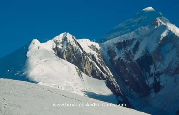
Seen from Nagar and Hunza, the northwest face of Spantik is a sheer pillar of pale marble and granite. At sunset it catches the last light and glows a deep yellow, which earned the mountain its nickname, the Golden Peak. That face, known as the Golden Pillar, is one of the most celebrated hard climbs in the Karakoram. The British climbers Mick Fowler and Victor Saunders made its first ascent in 1987.
The normal route is on the opposite side of the mountain and is a completely different proposition.
Spantik at a Glance
| Detail | Information |
|---|---|
| Height | 7,027 m (23,054 ft) |
| Range | Spantik Sosbun, Karakoram |
| Location | Between Nagar and Shigar, Gilgit-Baltistan |
| First ascent | 1955, by a German expedition led by Karl Kramer |
| Standard route | Southeast ridge from the Chogolungma Glacier |
| Base camp | About 4,300 m |
| High camps | Three |
| Expedition length | Around 28 to 32 days from Islamabad |
| Best season | June to August |
A Short Climbing History
The American explorers Fanny Bullock Workman and William Hunter Workman explored the Chogolungma Glacier in the early 1900s and attempted Spantik, reaching a high point on the ridge. The first confirmed ascent came in 1955, when a German team led by Karl Kramer climbed the southeast ridge. That line remains the standard route today and has been climbed by many teams, including a growing number of Pakistani mountaineers.
The Approach to Spantik Base Camp
Skardu to Arandu
After a day or two in Skardu for permits and final preparations, jeeps carry the team through the Shigar Valley and along the Basha River to Arandu, a traditional Balti village at about 2,770 metres. The drive takes six to seven hours.
Arandu to Base Camp
From Arandu the trek follows the northern edge of the Chogolungma Glacier, one of the longer glaciers of the Karakoram. It usually takes three days, with camps at Chogo Brangsa and Bolocho, to reach base camp at around 4,300 metres. The walk is easier than the Baltoro, with grassy ablation valleys, wildflowers and shepherds’ huts for much of the way. Base camp sits on a pleasant spot beside the glacier with running water and clear views of the route.
The Standard Route: Southeast Ridge
The southeast ridge is long rather than steep. From base camp to summit you gain about 2,700 metres over a distance of roughly eight kilometres, using three camps.
Base Camp to Camp 1
A steep path over scree and rock leads to Camp 1 at about 5,050 metres, on the crest of the ridge. This section is mostly snow free in midsummer and takes three to four hours.
Camp 1 to Camp 2
Above Camp 1 the route follows a broad, undulating snow ridge. There are several rises and dips, and a few short, steeper steps where fixed rope is helpful. Camp 2 is placed at around 5,500 metres. The distance is longer than the height gain suggests, and soft afternoon snow can make it tiring.
Camp 2 to Camp 3
This is the steepest part of the climb. A snow and ice slope of up to about 45 degrees leads to a wide plateau and Camp 3 at roughly 6,300 metres. Fixed ropes are normally placed here, and some crevasses must be crossed or avoided.
Summit Day
From Camp 3, climbers cross the upper plateau and follow the final summit ridge. The ground is not technical, but the day is long, typically 10 to 14 hours for the round trip, and deep snow can slow progress considerably. On a clear morning the summit view takes in K2, Nanga Parbat, Rakaposhi and Diran, along with a sea of lesser peaks.
How Difficult Is Spantik?
Spantik is regarded as one of the most accessible 7,000 metre peaks in Pakistan. The standard route has no sustained technical climbing, the approach is short, and the objective dangers are lower than on many Karakoram mountains.
That does not make it easy. Climbers need to be prepared for the following.
- Altitude. The summit is above 7,000 metres, and most teams climb without bottled oxygen.
- Distance. The ridge is long, and carrying loads between camps is hard work.
- Snow conditions. Fresh snow can make trail breaking exhausting and raises the avalanche risk on the slope below Camp 3.
- Weather. Storms can pin teams down for days.
- Crevasses. Rope travel is required above Camp 1.
Who Should Climb Spantik?
Spantik suits climbers who have already been to 6,000 metres, for example on Island Peak, Mera Peak, Lobuche East or one of the Andean volcanoes. You should be confident using crampons, an ice axe, a harness and ascenders on fixed ropes, and you should understand the basics of glacier travel.
For many mountaineers, Spantik is the ideal stepping stone towards an 8,000 metre peak. It teaches you how your body responds to extended time at altitude and how an expedition is run, at a far lower cost and risk than Broad Peak or Gasherbrum II.
Best Time to Climb
The climbing season runs from June to August. July offers the most reliable combination of settled weather and consolidated snow. In June there is often more snow on the lower ridge, and by late August conditions become colder and less predictable.
Permits and Paperwork
Because Spantik is higher than 6,500 metres, it requires a mountaineering permit and a mountaineering visa. Both are arranged through a licensed Pakistani operator. A government liaison officer is normally assigned to each expedition, and a briefing is held before departure.
The royalty for a peak in the 7,001 to 7,500 metre category is a small fraction of the fee charged for the 8,000 metre peaks, which is one reason Spantik is such good value. Fee schedules have been revised more than once recently, so we confirm the exact amount for each season at the time of booking.
A Typical Spantik Itinerary
| Days | Stage |
|---|---|
| 1 to 2 | Arrive in Islamabad and travel to Skardu |
| 3 | Briefing, permits and equipment check in Skardu |
| 4 | Drive to Arandu |
| 5 to 7 | Trek to base camp |
| 8 to 24 | Acclimatisation rotations and summit attempt |
| 25 to 27 | Trek back to Arandu and drive to Skardu |
| 28 to 30 | Return to Islamabad with spare days for weather |
What Support Do You Need on the Mountain?
Most teams climb Spantik with a local crew. At base camp, a cook and kitchen staff look after meals so climbers can rest properly between rotations. Above base camp, high altitude porters help carry tents, fuel and food to the upper camps and fix rope on the steeper ground below Camp 3. A satellite phone or messenger for weather forecasts and emergencies is strongly advised, since there is no mobile coverage beyond Arandu.
How to Prepare
Give yourself at least four to six months of structured training. Focus on long days in the hills with a heavy pack, steady aerobic work and leg strength. Practise your rope skills until they are automatic, since cold hands and thin air make simple tasks difficult. A good down suit or layered system, a sleeping bag rated to minus 30 degrees Celsius and properly fitted high altitude boots are essential.
Frequently Asked Questions
How high is Spantik?
Spantik is 7,027 metres high, which is 23,054 feet.
Where is Spantik Peak located?
Spantik is in the Karakoram range of Gilgit-Baltistan, Pakistan, between Nagar and the Shigar district. It is climbed from Arandu in the Basha Valley.
Is Spantik a good first 7,000 metre peak?
Yes. Its moderate standard route, short approach and relatively low objective danger make it one of the best introductions to 7,000 metre climbing.
How long does a Spantik expedition take?
Most expeditions last about 28 to 32 days from arrival in Islamabad to departure.
Do you need oxygen to climb Spantik?
No. The great majority of climbers reach the summit without supplemental oxygen, although emergency oxygen is usually carried.
Climb Spantik With a Local Expedition Team
A successful Spantik expedition depends on good acclimatisation, strong high altitude porters and patient weather calls. Our Skardu based team organises Spantik expeditions each summer with experienced Balti climbing staff. If the Golden Peak is on your list, get in touch and we will send you the full programme.
Last updated . Prices, dates and conditions can change, so confirm details with our team before booking.